Comings and Goings

August and September were months of comings and goings here.  We had the yearly group of Italian volunteers from Rome come for two weeks and leave at the end of August.  Meanwhile the first new Salesian Lay Missioner, Vivian, arrived towards the end of August.  Also Michelle, a Cochabamba Salesian volunteer, passed through Montero on her way to her site.

Extended community dinner (left to right): Tom, Michelle, Vivian, Aubrey, Ramona

Then the first week of September was a flurry of arrivals with Madre Clara, the big cheese, returning from her trip to Europe and three other Salesian volunteers arriving:  Maggie, Monica, and Tania.

Then too soon we had to say a sad goodbye to the outgoing Salesian volunteers, Aubrey and Ramona.

Then two weeks later Lainie arrived and finally AnnMarie (a repeat volunteer from last year)!  Now we’re a group of 8.  Each person brings their own talents and skills to offer and each is staying a different amount of time so the experiences differ but we all travel down the same road together for this brief period of time.

Sunday night community dinner (left to right): Tania, Lainie, Maggie, Monica, Vivian, AnnMarie, Tom.  And I’m taking the picture.

Oh the things they will make

So Bolivia actually has an interesting relationship with China since basically everything that is sold here (and everywhere right?) is from China.  But it’s a common thing to say to someone, “Is that real or is it Chinese” as a way to inquire about the quality of something.  It’s gotten to the point that “Chinese” is synonymous with “poor quality” even when referring to things not made in China.  They also like to use the phrase “work like a Chinese man” to indicate someone working extremely long hours in poor conditions.  At first I was shocked at how un-pc these comments were, particularly since people here have very little knowledge about what China is actually like and have met very few, if any, Chinese people.  But there’s no word I know of for ‘pc’ in Bolivian spanish, so I just let it go.

Some of the products that come to Bolivia I’m certain would never be accepted for import into the U.S.  One example of which is this darling pregnant barbie doll called “Happy Every Day.”

Not to be outdone, we saw another package with the same pregnant barbie dolled labeled “Teenage Pregnancy Beautiful.”  We all let out a collective What!? when we saw that one, but unfortunately couldn’t get a picture.

Another fun story is the kite Tom bought.  He was really excited to try it out the next day but was disappointed when it wouldn’t actually fly.  As he put it, “It seems as if someone who had seen a kite before said oh I can make that but didn’t actually understand the concept.”  The directions on the package should have probably been a tip off to us.  “CAUTION: Fly your kite in large field, avolding your kite the railway.  Trafficroad, the eletrlc line and high pressure wire field, vallay or near airport.  Made in China.”

Fires, Drought and Rainforest

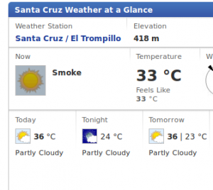
So we’ve already started the hot, dry, smoky season here.  Generally it’s smoky because they burn the sugar cane fields and the processing plant to the north of us throws out a lot of ash and smoke while processing the sugar cane.  However as we’ve found out happened in 2010 when we first got here and is happening again this year, in dry years the fires get worse.  Similar to what happened in the US this year, fires have started getting out of control in Bolivia.  When these fires get out of control in rural areas, there’s little more than men with buckets and rugs to beat them back.  Just a few days ago a huge chunk of land owned by the Santa Cruz airport burned out of control but luckily the airport has firefighters and were able to keep stop it before it got to the airport.

Many of these fires are human-started.  The majority of the fires are in the department of Santa Cruz (us) and the department of Beni (north of La Paz).  According to a recent article in our newspaper El Deber, the vast majority of the burning is associated with cattle farming and agriculture.  Why these fires started is a more difficult question though.  We know that farmers burn forest to clear the land; they also burn trash and according to the newspaper today, many farmers have claimed the fires came across the border from Brazil.  However since the same article said the authorities were fining anyone found starting fires, the truth is probably getting buried.  Burning can also be part of the yearly harvest cycle for crops such as sugar cane and what starts as a controlled burn could get out of control.  Beni and Santa Cruz are the main agro-business regions in Bolivia so it would make sense that so much burning is centered here, particularly during sugar cane harvest.

So we have man-made fires burning out of control with inadequate ability to fight them, but the problem doesn’t stop there.  Coincidentally the departments of Beni and Santa Cruz are also the regions where the Amazon rainforest spills down into Bolivia.   And as a recent article picked up by nbc.com, “Bolivia park declared one of most diverse places on Earth” explains nicely, this region has huge biodiversity significance.  You know the stories about a scientist going deep into the rainforest and finding some fungus that cures this disease or that disease.  This is that forest.  El Deber reports that since January over 1000 fires occurred in forest reserves and protected areas.  (How large those fires were is not clearly explained however).  I don’t believe Madidi National Park, which the nbc article talks about, has had any large fires but they are certainly not out of danger.

They say it might rain on Wednesday.  Let’s hope it does.  Our weather forecast today:

Julia’s visit Part 2

After our adventures in Valle Sacta, we came back to Montero and showed Julia around a little bit.  It happened to be National Teacher’s Day and so she came to the Kinder and partied with us.

Julia and Nayerly dancing.  She also stopped by my English class and talked with one of my students.

My student said afterwards, “she so different from you.  She’s really happy and smiley.”  Oh, I thought, I guess I should try to smile more in my English class.

We also took Julia to Santa Cruz for a day to see the plaza, cathedral and most exciting of all, the feria.  The feria is a huge outdoor/indoor shopping center that’s open Wednesdays and Saturdays and sells everything you could ever want in bulk.  But it’s a collection of thousands of small vendors instead of a big box store like Costco.  It’s a great place to find all your illegal or fake merchandise.  I got a sweater for $10 that came with a tag on it that said 34.95 Euros!  Of course the guy offered me a cheaper price if I bought by the dozen, but I didn’t need a dozen sweaters.  And for Julia’s birthday present we found her a snazzy faux-Coach purse.

Julia was such a trooper what with us dragging her all over the country, being offered sketchy food, and braving the craziness of the feria.  It was really fun to have a visitor willing to come experience the real Bolivia with us.  Thanks for the visit Julia!


Julia’s visit

This post is waaaay overdue but better late than never right? The first week of June we had a visitor, my sister Julia! She was traveling to celebrate her 30th birthday and stayed here in Montero with us for four days. Sister Clara got excited about her coming and so decided we had to take her to visit Valle Sacta. Tom and I had never been either so I said sure, let’s go.

So after Julia arrived at 2am in the morning, and we all slept only 4 hours, we piled into the Sister’s truck and headed north. Valle Sacta is a small town half way between Montero and Cochabamba. It’s on the very edge of the foothills of the Andes in a very tropical and productive area. There had been some drug crack-downs that week, as reported in the newspaper, and we had the good luck to get to drive through all of the major cocaine-producing cities in Bolivia as well as the stolen-car capital of Bolivia. Since this area is a fair distance from any big city it tends to be a little farther from the reach of organized governance.

So with all that in mind, we were pleasantly surprised to see how beautiful the Sister’s compound in Sacta is. They have a huge K-12 school, a medical center, a girl’s home, a church, and a big convent house. We relaxed the first night and then in the morning we ‘made the rounds’ with the sisters, visiting all their programs. In the medical center a woman had just given birth that morning and the only staff there at the time were two nurses and a dentist. The baby couldn’t have been more than an hour old as the nurses were still mopping up the birthing room as we passed by and poked our heads in.

Then we visited the high school’s morning lineup.

We even drove out into the country to visit a three-room school house that’s under the umbrella of the main school in town. They were having a ground-breaking celebration for a new computer classroom they raised the money to build. It was a really great cultural experience. After the dance presentations and the speeches (I had to give a speech for us), the ground-breaking began. Everybody dug a little bit of the hole.

Then they put the ‘cornerstone’ in and we dropped clay pots full of chicha (fermented corn alcohol) against it. This is an offering to Pacha Mama and also is supposed to give good luck and a speedy finish to the building.  I was invited to throw a pot in and I’m proud to say it broke perfectly.  The guy before me didn’t break his pot and ended up spilling chicha all over Madre Clara.  It can be seen as a bad omen if the pot doesn’t break.

At the end of any celebration, people throw confetti on everyone’s head. Here’s Julia with some of the students.

Then we toured the school, they had three computers set up in a classroom to show off.

And they insisted we stay for lunch which was corn (choclo), homemade cheese, potatoes and habas which are like big lima beans. Julia and I shared a plate and were able to finish everything except the cheese which we deemed too risky. The food was simple but really good and filling. And as is the custom in many parts of Bolivia, it’s all eaten with your hands, no utensils needed.

And that was just the morning!  We went back and took a nap and then that afternoon we went to see the river, a tributary of the Amazon, at Puerto Villaroel.

I realized after this picture that the Sisters must not know what I was doing, so I tried to explain was a moose was, but I ran out of words quickly and just gave up.  Fishing is a big industry for this town and so there were many boats on the river. It appeared that most people who owned a boat also lived on the boat at least for some period of time.

Last Class

We’re now a couple weeks into our last semester teaching in Montero, and it has been very busy.  For the first time, my Introduction to Multimedia class had to turn away students because the class was full!

I’d especially like to thank everyone who donated towards building this computer lab. When we originally put it in, I only wanted to install ten computers, but Sister Clara (who runs the school) thought we should try to do fourteen, and because so many people donated towards it we were able to put them all in.

Now I just have to do my part and teach the class. Having a larger class is definitely a lot more work because I need to spend a substantial part of the time giving one-on-one instruction. It’s challenging, but it’s a challenge I’m excited for. Keep me in your prayers please.

I also have a new section this semester. Every Saturday morning I have a class with several of the sisters. It’s a little more laid back (only 3hrs a week vs. 10 for a normal class) but they’re learning some good fundamentals of multimedia as well as some basic computer usage. And it doesn’t matter how much they beg me for it, I’m not letting them make up missed homework with extra rosaries!

Making Maps

A quick note: The blog has had some hiccups over the last month and a half, sorry for any readers who couldn’t get access. I think I now have things worked out with our hosting provider and it should be better. We should have some more new material coming soon!

Making Maps – The First Step in Development

Having used google maps for years (and before that mapquest), I expected, in 2010 when I came to Bolivia, that a city of 100,000 people like Montero (wikipedia, better version) would certainly have some online maps that I could look at before I arrived. I was hoping to scope things out, see where I would be living and working, what was around, where I could put my skills to work, etc.  Unfortunately there wasn’t anything.  Google maps had a spot for montero, and a few of the roads, but not very many and almost no street names or any other kind of reference spot.  My personal favorite mapping spot, OpenStreetMap, was even worse off, it just had the main road through town (which I would later find out wasn’t even done correctly).

So when I got to Montero, not only did I not know what the town would be like, but we had the most difficult time finding my way around for the first couple months. After a while of this, I decided to take matters into my own hands and build a map of the town.  In addition to being able to find great fried chicken places a second time, I was hopeful that my map would also be of use to others. I know that there are several NGOs that work on a regular basis in and around Montero and it would be great if they could build off of my work as well. Eventually, I hope that as Bolivians become more and more computer literate, they could also benefit from having a decent map of their city. (Spoiler: here’s the link)

I decided to do my work in the OpenStreetMap database for two reasons: 1) they have great map making tools (both online and offline), which I was already familiar with and 2) the maps would be made freely available to anyone who wanted them.  For those not familiar with it, the OpenStreetMap (OSM) project works like wikipedia. Anyone can edit it and there is a huge community focused around making it better (and keeping it free of vandalism).

Being lazy, I started creating my map near where I was living. I’d go out early in the morning (before it got super hot) and wander around the streets near where I lived with my GPS running and a camera I used to take pictures some of the plaques that the city had put on every house. These had on them the address for that house and many had, crucially, the names of the streets. I had tried to write down the names, but that resulted in me standing in front of someone’s front door for a minute while I tried to write down spanish names. Using the camera allowed me to take just two seconds per door and resulted in a lot fewer strange looks.
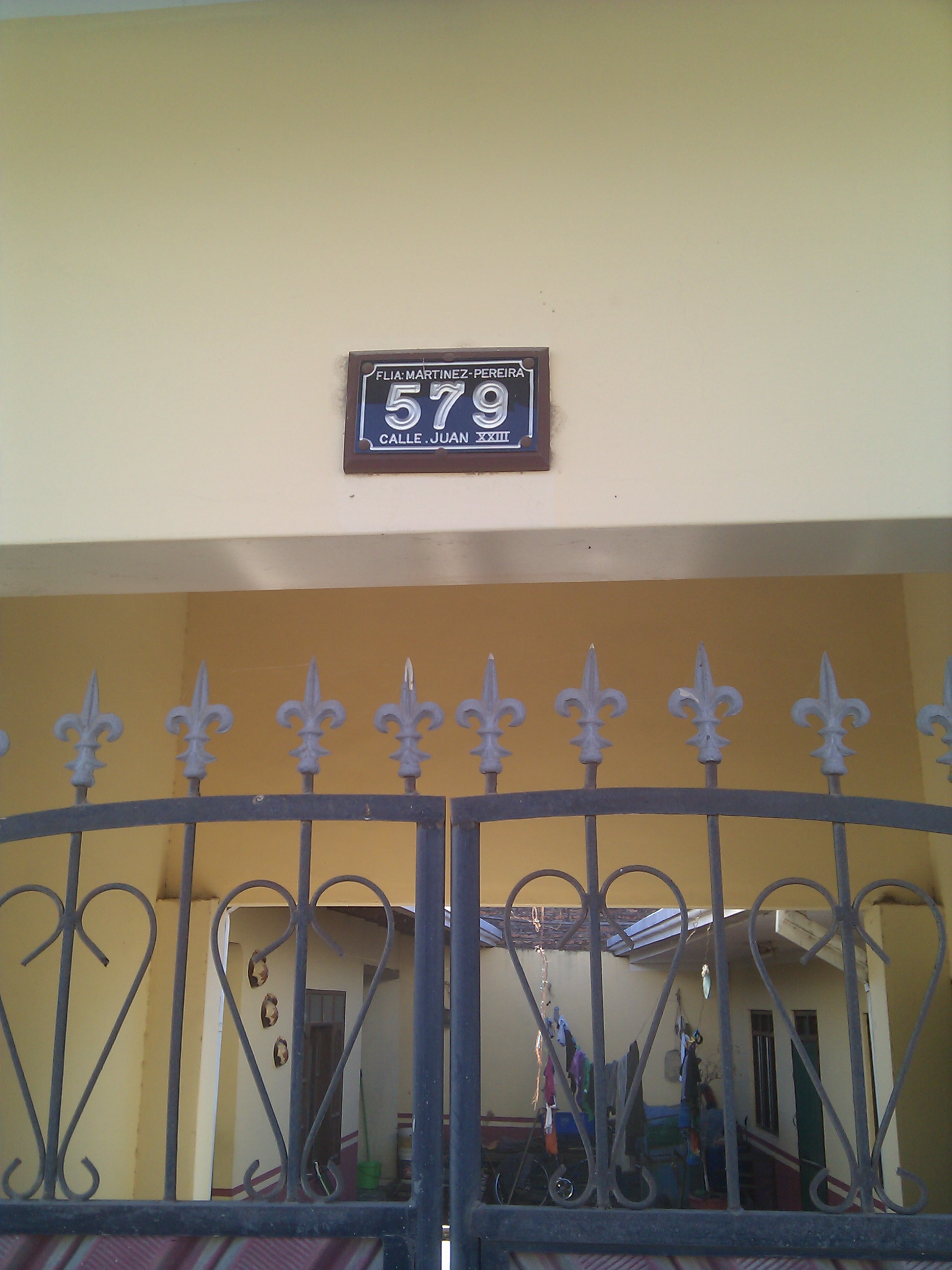
An address plaque that has a street name on it.

Once I’d get back home, I’d convert my GPS track into the common GPX format (also wikipedia) which is a common, computer readable, format for GPS data. Once I had the GPX file, I would do two things with it. The first is to simply upload it to the OSM server so it would be available for use later. Then I would open it together with my pictures in a program called Viking. This program (and there are many others like it) could use the timestamp (assuming I had previous set the correct time on my camera plus or minus a few seconds) on my pictures to put them onto my GPS track. Now I could see which of the lines in my track (aka streets) had which names.

I would start up the online editor on the OSM website. To make streets here is very easy, I would start by clicking on the end of one street to make a point, then just click a few points along my track (more if there were turns) until I got to the end and OSM automatically connects them into a line. Finally, I would simply select the type of street: dirt road, paved road, various classes of highway, etc. (What these classifications mean varies from country to country, for example here they are in Brasil.)

Once I had all the lines for streets input into OSM, it was time to add their names. By looking at my GPS trace with the pictures at the same time as my new map, it was easy to see which picture corresponded with which road. All I had to do was read the picture and type it into the road name box.

I didn’t spend too much time on this right away, which turned out to be a good thing, because about a month after I got started OSM got sponsorship from Microsoft. Part of this deal meant that satellite imagery which Microsoft had would be available in OSM’s online editor. Now instead of walking up and down each street, I could just sit at my computer and draw the street lines where the satellite images showed the streets going.  Much easier!  The downside to this is that the satellite imagery didn’t line up quite right. It turned out that all the images were about 30ft north of where they were supposed to be, not terrible, but enough that it stood out on the GPS. To solve this I went to various points around town that were easily visible in the satellite imagery (I really only needed one or two though) and took careful GPS positions of them. Then I used these as control points to show me how far I needed to adjust my lines.

Now that I could make all the street lines from my computer things went much faster. After four hours of furious clicking, I had all the street lines in the main part of the city.  A few more days of on-and-off work gave me the rest of Montero and a bunch of the surrounding area. The map was looking very good, unfortunately only the streets near where I lived had names. To fix this, I went back to my walking around with a camera and taking pictures of address plaques, but it went much quicker now. I only needed to hit one house on each street.  I was able to walk a zig-zag path from the edge of town into the center and got all the street names in that quarter of the city!

In addition to streets OSM also has built in support for all kinds of points-of-interest from resturants to churches to drug-stores.  Its easy to add them in the editor, just select one and drag it in, and now that I had a map with streets and names, it was easy to figure out where to put things. If I knew that the grocery store was on Calle Warnes a block up from the main plaza, I could just add places from memory. After putting in my favorite/important places, I was considering my map complete!

This is about where it stands now, you can see it here:
http://www.openstreetmap.org/?lat=-17.3315&lon=-63.2577&zoom=14&layers=M

This is great, now when I find a great new fried chicken place, I know where to put it so I can find it again!  However, the uses of the map aren’t limited to finding restaurants or getting around town. OSM provides all the map data freely to anyone who wants to use it, so it can be imported into other programs and used as a base to add other map related information, such as population density, disease outbreaks, crime rates, etc. Then this data can be used to make important development decisions. This is really a whole field, which is called Geographic Information Systems (GIS), but you don’t need to be getting a graduate degree in it (like my brother who starts his masters in GIS next week…good luck Kevin!) to put it to use.

So if you are one of the EWB people reading this blog or otherwise work in international development, think about making a map of the whole community/region as your first step in working on a project. Its easy, and a lot of work can be done state-side before you head into the country.

Tomas(a) dancing

Tom’s not the only one with dance videos up his sleeve.   The next evening we went to the Sacred Heart party at the girls home (Hogar).  The girls presented a variety a well-rehearsed dance numbers.

Even the staff had a great number.

And we presented this number. See if you can pick us out.


Get
the Flash Player
to see this video.

Get it in 720p.
Also on Youtube

Laura Dancing

So this week was the Feast of the Sacred Heart, from which the order of sisters we work with take their name. Its been several days of busyness and excitement (with more still to come).  Thursday night the sisters had a party for the parish, which was mostly attended by the youth. All the different youth groups did a performance.

Here’s on of the larger groups.

One group did a more traditional dance.

The group Laura works with did a play as mimes.

Even the Sisters got into it.

However, you may notice that the title of this post isn’t about the feast or the party…I took a bit of video of Laura dancing, and wasn’t going to post it all (at least together) but as you’ll see it came to that.

Get
the Flash Player
to see this video.

Get it in 720p.
Also on Youtube


Just to show that I’m not that bad of a guy, I’ve also got a picture of me (the ridiculously tall one…those are mostly fully-grown Bolivians) trying to dance.

It’s the end of the world as we know it…and I feel fine.

I couldn’t let this momentous occasion pass without sharing it with all of you.  As of 2:00 pm May 30, 2012 Tom and I never have to go to the Bolivian Immigration office EVER again.  The visa process has been a continuing stress for us since our arrival in September 2010.  Document after document, hours upon hours spent waiting in lines (I’m talking over 15 hours, just in line time) hours of traveling, significant money spent and sleep lost, all of this culminating in our most recent government ID process.

So a funny thing happened in March.  The Bolivian Immigration office, which serves the whole region of Santa Cruz, packed up one night and moved silently across town leaving not so much as a sign about where they had gone.  The taxi drivers didn’t know, the bus drivers didn’t know and we certainly didn’t know.  The other volunteers were there days before the office moved and said no one informed them in any way nor did they see any informational signs about it.  And beyond that, they splintered off the government ID department to a third location.  So after a bit of hassle we located the new offices, one in the first ring, the other in the fourth ring.  We pick up our passports in the first ring office and head out to the fourth ring office to apply for IDs.  It’s a well demarcated, stately office.  lol oh wait no, it’s a house on a muddy, back-road residential street with a letter-sized piece of white paper for a sign.

It’s like they don’t want you to find it.

And when we arrive at 9:00am we’re told they’ve already given out all the numbers for the day and that we have to arrive at 6:00am if we want to be helped.  Ok, fine so a few days later we get up at 4:30am, get the first shared taxi out of Montero at 5:15am and arrive in line at 6:15am.  The office is supposed to open at 7am and there’s already a significant line, and I’m already crabby.  No where to sit so we stand and stand.  A secretary shows up at 7:10am but says she doesn’t have the key.  Finally the lady with the key strolls in at 7:30am.  We receive our numbers, 21 and 22 and we’re told that they probably won’t get to us until 11am so we can go and come back.  So we go and sit in a coffee shop and read for awhile.  At 11am we went back and experienced first hand the glacial pace at which the office functioned but we got our stuff in a-ok and were headed for lunch by noon.

We were told to come back May 30th to pick them up but pick up is only possible between 2pm and 3pm.  So we went and we got them and we don’t plan to go back ever!